Offering a fine group of original 1893 folio maps from the “Atlas to Accompany the Official Records of the Union and Confederate Armies”, a comprehensive record of detail during the four years of the Civil War. 29-1/2″ x 18-1/2″. These are in overall excellent antique condition. Never openly sold, being distributed only to Federal depositories & other institutions.
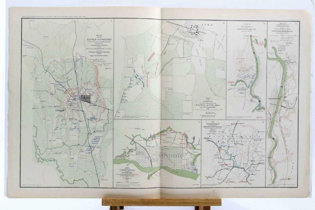
- FEATURING here an original 1893 lithograph plate XXV, featuring 6 Civil War Battles & Entrenchment Maps from 1862 between the Confederate and Union Forces.
- Includes Plan of the Battle of Corinth, Map of the Battle of Iuka, and more.
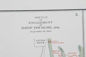
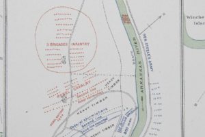
- Lots of details, positions of pontoon bridges and guns at Fredericksburg, and a sketch of the engagement at Bayou Fourche in 1863.
- This piece is in VERY good overall antique condition, with age-yellowing and very minor edge wear as shown.
- Please see photos for details.
- It will be shipped in a tube for safety.
HISTORY: Original folio map of “The Atlas to Accompany the Official Records of the
Union and Confederate Armies,” commissioned and published by Resolution of the United States Congress of May 19, 1864. Entered as the historical record into the Library of Congress. The atlas illustrated therein a comprehensive record of all battles and skirmishes, troop positions, and intricate geographic and topographic detail for all four years of conflict. The atlas was never openly sold; it was distributed only to Federal Depositories, Universities, Libraries, Museums, and other Public Institutions. Only during the last century were the maps released into the public domain. Of the 10,000 published atlases, fewer than 1,000 remain complete.
Original 1893 lithograph plate from “The Official Atlas to Accompany the Official Records of the Union and Confederate Armies”. Commissioned by Resolution of the United States Congress of May 19, 1864, by which Adjt. General Townsend was Appointed Director of its Collection and Preparation. Upon the passing of General Townsend, the Compilation and Accumulation of maps and records continued through three Presidential Administrations and under the direction of three Secretaries of War: the Hon. Redfield Proctor, Stephen B. Elkins, and Daniel S. Lamont, and attended by its Board of Publication led by Major George B. Davis, U.S. Army, Leslie J. Perry, and Joseph W. Kirkley. They ultimately compiled and published, between 1891 and 1895, under Captain Calvin D. Cowles, in two maroon folio volumes, with 35 parts set on 5 lithograph plates, totaling 175. Each was engraved by Master Printer Julius Bien & Company. The compilation and assembly of the atlas took over 30 years. Ten different Civil War pieces of history are available in our eBay Store Connectibles.